https://www.clearlakeragbrai.com/
Being the planner that I am (my father's daughter), I have a game plan. With 10,000 tired cyclists rolling into town each evening at staggered intervals, many will just fly by the seat of their sweaty cycling shorts and follow signage once they get there and grab the first available options. Not I...
I also plan to locate the phone charging stations in advance so perhaps I can plug mine in on the way INTO town before the lines get long. Finally, I want to know where the showers are. The ones in the main campsite will likely have long waits and run out of hot water fast. I have noted the locations of the satellite/overflow campgrounds and can walk there once I have ditched my heavy stuff near the transport truck. Once I set up my tent, I'm happy to head into town for food, beer gardens, a shower or swim and live bands and just wing it and relax while sipping on a cold rejuvenating beer ;) Of course, seasoned riders will be doing the same thing, but hey... if I can get ahead of a few hundred non-planners, I'm that much better off.
They say to bring a small pad lock to secure your phone/iPad while charging. Done!
Here are links to some of the town maps with their amenity legends:
http://www.algonaragbrai.org/uploads/9/9/7/1/99714072/ahs_camp_map.jpg (Algona)
https://ragbrai.orangecityiowa.com/maps/ (Orange City)
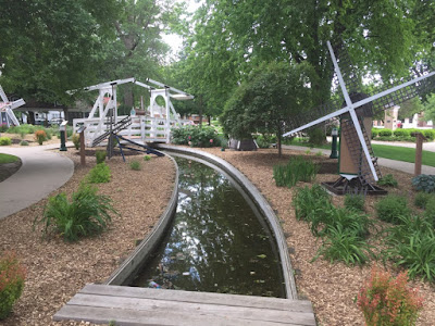
It is customary before the ride starts to dip you rear wheel in the western Iowa border river, this year, the Big Sioux River. Rather than ride 31 miles each way to the river from the start town of Orange City on 7/22, I'm opting for an easier option. The town of Orange City is actually transporting Missouri River water to fill the canal in their centrally located and picturesque Windmill park! How cool ;)


No comments:
Post a Comment